Description
What is a Passive GPS Antenna Flexible PCB Built-in Antenna?
The Built-in antenna Passive GPS Antenna CTRF-ANTENNA-GPS-1575-2515-IPEX item Flexible PCB Antenna is manufactured by C&T RF Antennas Inc, a direct passive & active GPS antenna factory in China.
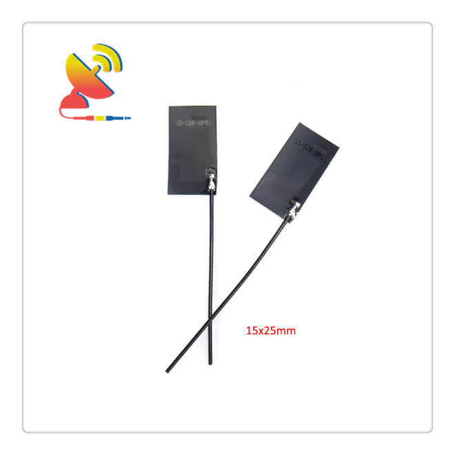
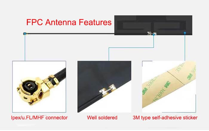
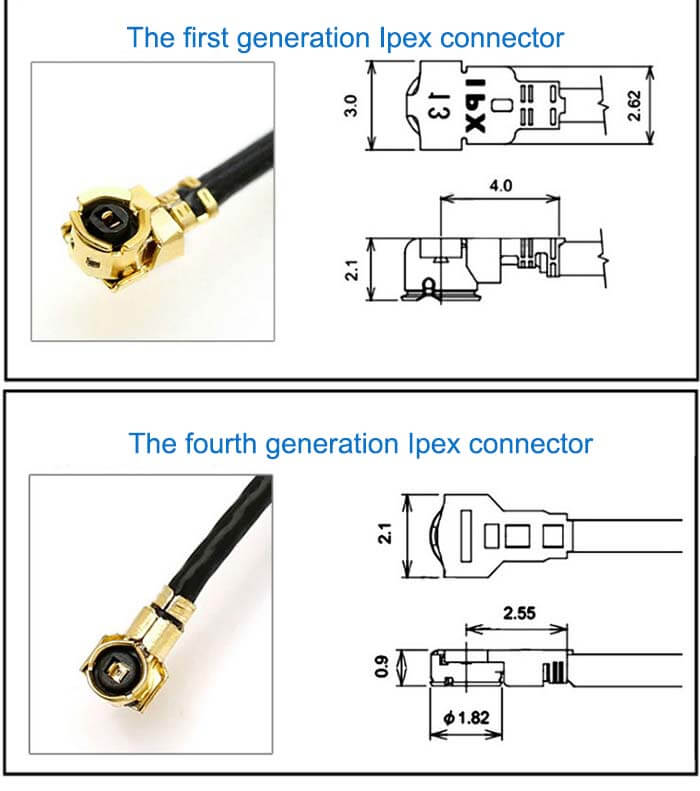
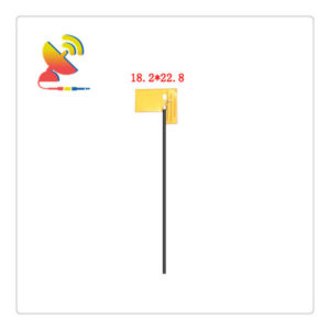
The Passive GPS Antenna Flexible PCB Built-in Antenna comes with a small size of 25x15mm and RG 1.13 coaxial cable U.FL Ipex connector antenna.
GPS/GLONASS/BeiDou/Galileo Flexible ultra-thin PCB Adhesive Antennas are available at C&T RF Antennas Inc.
C&T RF Antennas Inc provides internal & external antennas with the antenna radio frequencies such as NFC, 169MHz, 230MHz, 315MHz, 433MHz, 868MHz, 915MHz, VHF&UHF, Lora, NB-IoT, ADS-B, GSM, GNSS, Wifi 2.4GHz, 5.8GHz, Cellular 2G 3G 4G LTE, GPS, 5G NR, etc.
C&T RF Antennas Inc. provides RF antennae with Omni & Directional antenna types such as Dipole Antennas, Whip Antennas, Marine Antennas, Router Antennas, MIMO Antennas, Combo Antennas, PCB Antennas, FPC Antennas, Spring Antennas, Magnetic Antennas, Sector Antennas, Yagi Antennas, and Accessories, etc, for IoT & M2M industries.
Please contact us for more details such as the Passive GPS Antenna datasheet, Passive GPS Antenna pricing, Passive GPS Antenna inventory, or other Passive GPS Antenna styles.
Passive GPS Antenna Flexible PCB Antenna Specifications
Passive GPS Antenna Flexible PCB Antenna Electronical Specifications |
|
| RF Antenna Type | GPS Antenna |
| Model | CTRF-ANTENNA-GPS-1575-2515-IPEX |
| Frequency | 1575.42 MHz |
| Gain | 2dBi |
| VSWR | ≤2.0 |
| Impedance | 50 Ω |
| Polarization | Right Hand Circular Polarization/Omni |
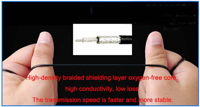
| Cable | RG1.13mm |
| Cable Length | 120mm |
| Connector | U.FL/IPEX/MHF |
| Lightning Protection | DC Ground |
Passive GPS Antenna Flexible PCB Antenna Mechanical Specifications |
|
| Dimension | 25x12mm |
| Weight | Approx. 3g |
| Material | FPC |
| Operation Temperature | -40˚C ~ +85˚C |
| Storage Temperature | -40˚C ~ +70˚C |
| Color | Black |
| Antenna Form | Passive |
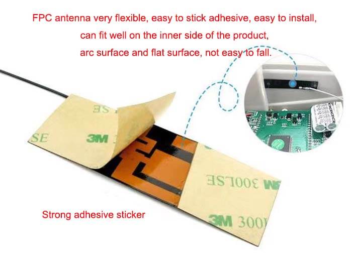
| Mounting | Sticker/Connector |
| Safety Emission and other | RoHS Compliant |
| Applications | GPS/GNSS |
Internal Car Antenna Passive GPS Antenna Features

GPS positioning accuracy
Twenty-eight satellites (four of them are in reserve) have already been launched, distributed on six orbital planes separated by 60 degrees, about 20,000 kilometers from the ground.
It has achieved a single-machine navigation accuracy of about 10 meters, and the accuracy of the integrated positioning can reach centimeter and millimeter levels. However, the accuracy of the civil field opening is about 10 meters.
GPS settings
GPS is available, if it is a new machine to locate, it has already been mentioned. In addition, there are some settings. Commonly used are coordinate systems, map references, reference orientations, metric system/imperial systems, and data interface formats.
Coordinate system: LAT/LON and UTM are commonly used. LAT/LON means latitude and longitude, and UTM doesn’t care about it here.
Map datum: WGS84 is generally used.
Reference direction: There are actually two norths, magnetic north and true north (abbreviated as CB and ZBY). The north pointed by the compass is magnetic north, and the north pointed by the big dipper is true north. The angles of the two are different in different regions. The north on the map is the true north.
Metric/English: Optional.
Data interface format: This has to be discussed in detail. GPS can output real-time positioning data for other devices to use, which involves a data exchange protocol.
Almost all GPS receivers follow the standard specifications specified by the National Marine Electronics Association, which establishes a communication standard between all marine electronic instruments, including the format of transmission data and the communication protocol for the transmission of data.
There are three NMEA protocols: 0180, 0182, and 0183. 0183 can be considered a superset of the first two and is being widely used.
Representation of latitude and longitude
Let’s talk about data representation. Generally, the data obtained from GPS is latitude and longitude. There are many ways to express latitude and longitude.
1.) ddd.ddddd, the decimal fraction of degree. Degree (5 digits)
2.) ddd.mm.mmm, the decimal fraction of degrees. minutes. minutes (3 digits)
3.) ddd.mm.ss, degrees. minutes. seconds
Not all GPSs have these types of displays. GPS315 can only choose the second and third types.
In the LAT/LON coordinate system, the latitude is evenly distributed, and there are 180 latitudes from the South Pole to the North Pole. The diameter of the earth is 12756KM, the perimeter is 12756*PI, and the latitude is 12756×PI /360 = 111.133 KM (inaccurate).
This is not the case for longitude. Only when the latitude is zero, that is, on the equator, the distance between a longitude is 111.319KM. As the latitude increases, the distance gets closer and closer and finally meets at the north and south poles. Therefore, the unit distance of longitude is closely related to the latitude where longitude is determined. The simple formula is:
Longitude 1° length=111.413cosφ, at latitude φ. (The formula is not precise)
Reviews
There are no reviews yet.