Description
What is a High-performance Active GPS GLONASS Antenna Magnet Antenna?
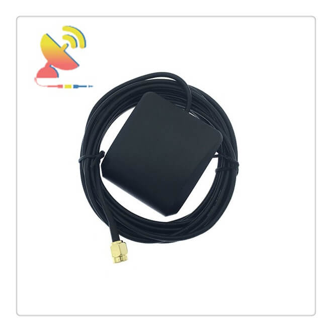
The High-performance Active GPS GLONASS Antenna Magnet Antenna CTRF-ANTENNA-GPS-1516-5550-SMA-2M is manufactured by C&T RF Antennas Inc and used for Marine, vehicles, Cars with magnetic mounts.
The next-generation version of the GPS Series Antenna, the CTRF-ANTENNA-GPS-1516-5550-SMA-2M Active GPS GLONASS Antenna Magnet Antenna adds GNSS capability to an industry-leading GPS antenna.
The GPS Series GPS/GNSS Antenna exhibits market-leading low current consumption and a waterproof IP66 design, making it a cost-effective solution for challenging outdoor applications looking to achieve high performance and durability.
The GPS antenna achieves half the power of competitive antennas, because of lower return loss and input voltage. This makes it ideal for battery-powered applications.
An integrated solution that offers several mounting and connector options, the CTRF-ANTENNA-GPS-1516-5550-SMA-2M Active GPS GLONASS Antenna Magnet Antenna offers multiple integration possibilities without having to create a custom part.
C&T RF Antennas Inc provides the IoT & M2M antennas with other radio frequencies such as 169MHz, 230MHz, 315MHz, 433MHz, 868MHz, 915MHz, VHF&UHF, Lora, NB-IoT, ADS-B, GSM, GNSS, 2.4GHz, 5.8GHz, 2G 3G 4G LTE, GPS, 5G NR, etc.
C&T RF Antennas Inc provides RF antennas with many antenna types, such as Dipole Antennas, Whip Antennas, Marine Antennas, Router Antennas, MIMO Antennas, PCB Antennas, FPC Antennas, Spring Antennas, etc.
Contact the C&T RF Antennas Inc sales team for datasheet, pricing, and inventory on the High-performance Active GPS GLONASS Antenna Magnetic Antenna.
High-performance Active GPS GLONASS Antenna Magnet Antenna Applications:
Asset Tracking & Monitoring
Oil & Gas
Smart Cities
Navigation
Power Distribution
Military/First Responders
High-performance Active GPS GLONASS Antenna Magnet Antenna Benefits
Superior multipath signal rejection
Great out-of-band signal rejection
Excellent signal-to-noise ratio
Consistent response in all operation temperatures
High-performance Active GPS GLONASS Antenna Magnet Antenna Specifications:
High-performance Active GPS GLONASS Antenna Magnet Antenna Electrical Specifications |
|
| RF Antenna Type | External GPS GLONASS Antenna |
| Model | CTRF-ANTENNA-GPS-1516-5550-SMA-2M |
| Frequency | 1575.42MHz,1602MHz |
| Gain | 42±2dBi |
| VSWR | ≤1.5 |
| Impedance | 50Ω |
| Polarization | Right Hand Circular Polarization |
| Cable Type | RG174 2m (1m, 3m) |
| Connector | SMA Male |
| Working Voltage | 3-5V |
| Axis ratio | 3.0dB |
| Frequency Temperature Coefficient | 0±10 |
| Humidity | 20% to 95% |
High-performance Active GPS GLONASS Antenna Magnet Antenna Mechanical Specifications |
|
| Housing Dimension | 55.5×50.5×17.5mm |
| Ceramic Dimension | 35x35x4mm |
| Weight | Approx. 150g |
| Radome Material | Plastic ABS |
| Operation Temperature | -40˚C ~ +75˚C |
| Storage Temperature | -40˚C ~ +80˚C |
| Finished Antenna Color | Black |
| Antenna Form | Active |
| Mounting | Magnetic and Screw |
| Safety Emission and other | RoHS Compliant |
| Applications | GPS, GLONASS |

What is GLONASS?
GLONASS is the abbreviation of “GLOBAL NAVIGATION SATELLITE SYSTEM” in Russian.
The function of the GLONASS satellite navigation system is similar to the GPS of the United States, the Galileo satellite positioning system of Europe, and the Beidou satellite navigation system of China.
GLONASS system structure
GLONASS is the first letter of Russian GLObalnaya NAvigatsionnaya Sputnikovaya Sistema. It has been officially launched globally on January 1, 2011.
According to the data provided by the Information Center of the Russian Federal Space Agency (October 10, 2012), there are currently 24 satellites in normal operation, 3 in maintenance, 3 in standby, and 1 in testing.
The standard configuration of the “GLONASS” system is 24 satellites, and 18 satellites can ensure that the system provides all services for users in Russia.
The system satellites are divided into two types, “GLONASS” and “GLONASS-M”. The latter has a longer service life, up to 7 years. The “GLONASS-K” satellite under development can operate for as long as 10 to 12 years.
The main function of GLONASS
The Global Navigation Satellite System (GLONASS) is a second-generation military satellite navigation system independently developed and controlled by the Soviet (now Russia) Ministry of Defense. Similar to the US GPS, this system also has a civilian window.
GLONASS technology can continuously provide high-precision three-dimensional position, three-dimensional speed, and time information for all kinds of military and civilian users in sea, land, air, and near-Earth space around the world.
GLONASS is superior in positioning, speed measurement, and timing accuracy to GPS after applying selective availability (SA) because Russia has promised to the International Civil Aviation and Maritime Organization that it will provide civilian navigation services to global users.
System composition of GLONASS
Satellite constellation
The GLONASS constellation consists of 21 working stars and 3 backup stars.
Therefore, the GLONASS constellation consists of 24 satellites. The 24 stars are evenly distributed on 3 nearly circular orbital planes. The three orbital planes are separated by 120 degrees. Each orbital plane has 8 satellites.
The satellites in the same plane are separated by 45 degrees. 23,600 kilometers, operating cycle of 11 hours and 15 minutes, orbital inclination of 64.8 degrees.
Scope of GLONASS application
Satellite navigation was first developed under the impetus of military demand. Like GPS, GLONASS can provide all-weather and continuous high-precision three-dimensional position, three-dimensional speed, and time information for various users in the world’s sea, land, air, and near-Earth space ( PVT information), which not only provides precise navigation for navy ships, air force aircraft, army tanks, armored vehicles, artillery vehicles, etc.;
It also provides precise guidance for guided missiles, C3I precise enemy-self situation generation, accurate force maneuvering and coordination, and precise targeting of weapon systems. Widely used in such aspects.
In addition, satellite navigation has more and more applications in various national economic fields, such as land and ocean surveying and mapping, post and telecommunications, geological prospecting, oil development, earthquake prediction, and ground traffic management.
The emergence of GLONASS broke the exclusive status of the United States for satellite navigation and eliminated the worries caused by the United States using GPS to inflict authority and deterrence on users.
GPS/GLONASS compatible use can provide better accuracy geometric factors and eliminate GPS SA Influence, thereby improving positioning accuracy.


Reviews
There are no reviews yet.